


Craigieburn Trails
Conor Boyd ITCraigieburn Trailsの説明
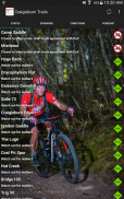
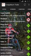
This app provides up-to-date information on track status within the Craigieburn Trails network, Castle Hill, New Zealand.
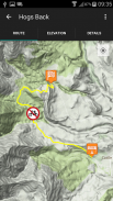
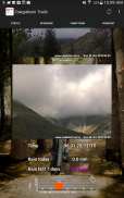
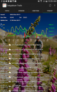
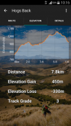
An in-app donation (choice of amount, with all proceeds going directly to track maintenance and development) will remove ads, unlock detailed maps, elevation charts and track descriptions for each trail in the network, along with Castle Hill webcams, and current & forecast weather conditions.
Permissions: this app requests permission to access your location to be able to display your location on map pages; this app requests permission to access the storage on your device purely for the purposes of caching data (e.g. map tiles).
Please be aware that the track map and elevation functionality require an initial data connection; if you're heading into an area of the Craigieburn Forest Park which has patchy coverage, visit the track details for the track you're interested in while you still have coverage and the data should be cached for offline use.
You can check mobile coverage in the Craigieburn Basin on the Vodafone website: https://www.vodafone.co.nz/network/coverage/
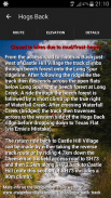
Some of the Craigieburn Trails suffer from frost heave during the colder parts of the year and, as a result, are considered closed to biking over the winter months (generally mid-late Autumn to early/mid Spring).
Trail users are asked to respect the status of the tracks (closed to bikes, closed for lambing, etc) as otherwise it means more work in the spring for our hard-working volunteers, and/or potentially diverting valuable donations/funding to unnecessary track maintenance when it could be going towards new track development.
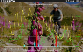
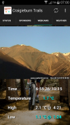
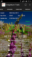
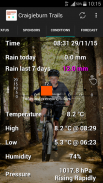
The current and forecast weather conditions at Castle Hill Village (including a chart showing rainfall over the preceding 7 days) are provided for you so that riders can follow the strong recommendation to stay off the tracks during or after rain.
Drop us a line via our website (or via in-app reporting feature) if there is more information you think should be included in this app.
Thanks also for your ongoing donations to the Craigieburn Trails.
Craigieburn Trails - バージョン 2.0
(10-06-2023)Craigieburn Trails- APK情報
APKバージョン: 2.0パッケージ: info.conorboyd.craigieburntrails.tracksCraigieburn Trailsの最新バージョン
他のバージョン


同じカテゴリのアプリ


